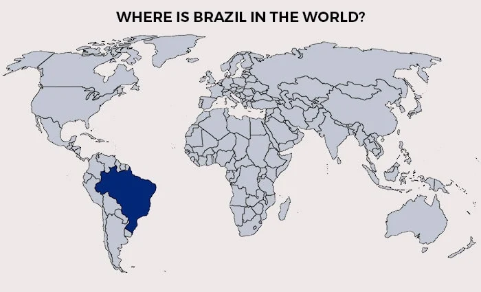
The map of Brazil is unmistakable, with its continental proportions. And this is just one of the interesting features of this territory, which is divided into regions totally different from each other.
Maybe because the country is so massive, but by merely crossing the border to another region, you can find a unique climate, cuisine, history, and culture.
And because I’m a Brazilian, I thought I could share some information about the states and regions of the Brazil map.
Also, I talk briefly about the evolution of the Brazilian territory, the biggest cities in the country, and a fun fact or two. (Because I love fun facts.)
Besides, I’m made available a few FREE detailed maps of Brazil for download at the bottom of this article. I hope you enjoy it.
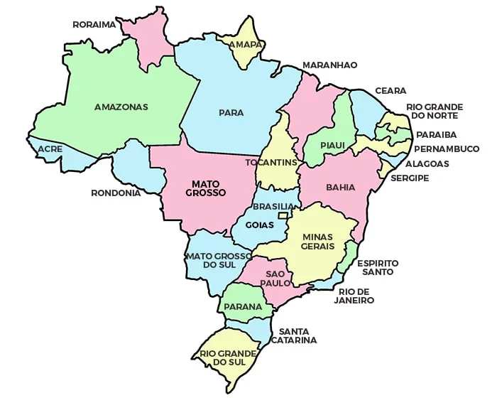
Brazil map
The map of Brazil represents a territory of just over 3.3 million sq mi (8.5 million sq km).
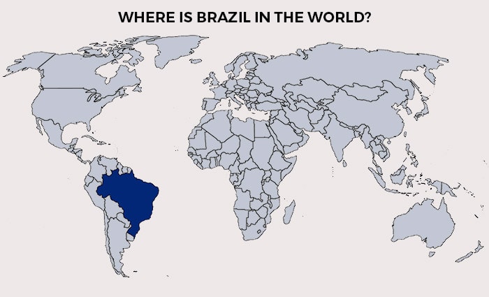
When analyzing Brazil’s geography, the country occupies half of South America. The highest point in Brazil is Pico da Neblina at 9,823ft (2.994m).
Much of the country is tropical, but the south is relatively temperate.

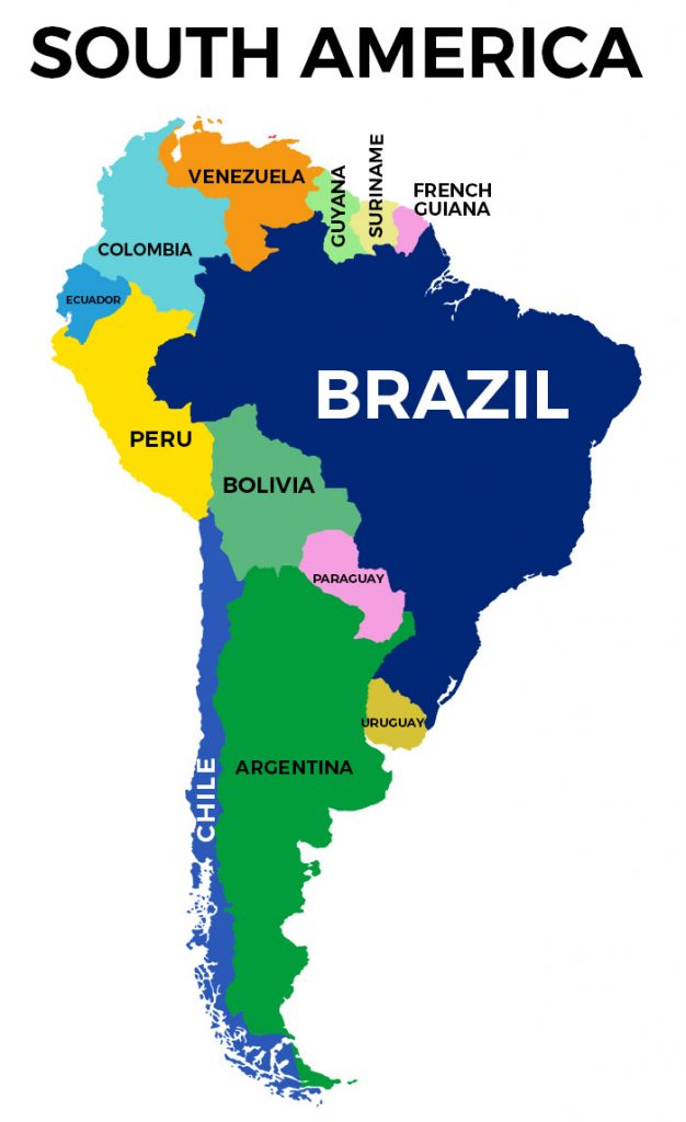
What are the countries that border Brazil?
The country borders Uruguay, Argentina, Paraguay, Bolivia, Peru, Colombia, Venezuela, Guyana, Suriname, and French Guiana.
When looking at the map of South America, Brazil is bathed by the Atlantic Ocean in the east, and surrounded by the other countries of South America in the west and northwest.

Brazil on a map: Regions
According to the Federal Constitution of 1988, the Federative Republic of Brazil is made up of 27 political units, of which 26 are states and one is the Federal District.
These 26 Brazilian states are divided into 5,570 counties spread across five distinct regions, and these divisions of the map of Brazil make evident the cultural, linguistic, and historical complexity of the country.
Now, let’s talk about each one region as well as the Brazilian map, states, and their respective capitals.

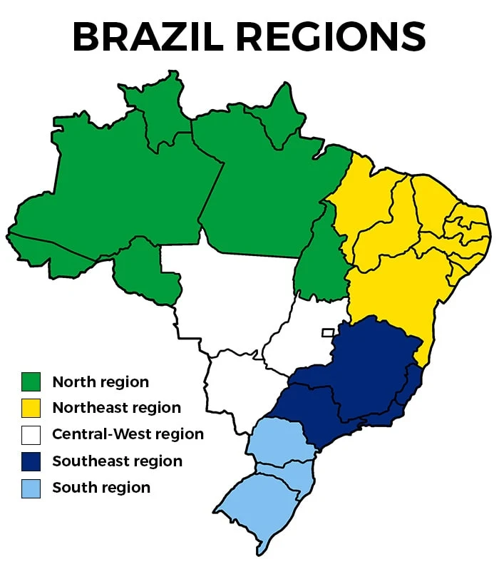
North
- Acre – Capital: Rio Branco
- Amapá – Capital: Macapá
- Amazonas – Capital: Manaus
- Pará – Capital: Belém
- Rondônia – Capital: Porto Velho
- Roraima – Capital: Boa Vista
- Tocantins – Capital: Palmas
The north of Brazil is a unique region with strong indigenous features and mesmerizing wildlife.
The biodiversity in the north, together with typical Brazilian fruits, make it a must-visit in the country. There’s no better way to experience Brazil than here.
Things to do in the north of Brazil:
- Get immersed in the indigenous culture of local communities.
- Visit the world’s largest rainforest.
- Spot the most incredible animals in Brazil (in the wild).
- Indulge in Brazilian fruits at Ver-o-Peso Market.
- Experience the unique meeting of the waters at the River Amazon.
Northeast
- Alagoas – Capital: Maceió
- Bahia – Capital: Salvador
- Ceará – Capital: Fortaleza
- Maranhão – Capital: São Luis
- Paraíba – Capital: João Pessoa
- Pernambuco – Capital: Recife
- Piauí – Capital: Teresina
- Rio Grande do Norte – Capital: Natal
- Sergipe – Capital: Aracajú
The northeast of Brazil was the entrance gate of the world during the colonial period, which explains the strong African roots in the region.
Capoeira, candomblé, and axé are only a few of the things we inherited from the African slaves brought to Brazil, and they are a massive part of the local culture.
Things to do in the northeast of Brazil:
- Indulge in delicious local dishes, such as acarajé, vatapá, seafood stew, and more.
- Learn how to dance-fight capoeira.
- Celebrate carnival and experience a sensory overload.
- Chill out in some of the prettiest beaches in Brazil.
- Hike in the lush green forest of Chapada Diamantina National Park.
Central-West
- Goiás – Capital: Goiânia
- Mato Grosso – Capital: Cuiabá
- Mato Grosso do Sul – Capital: Campo Grande
- Distrito Federal – Capital: Brasília
The central-west of Brazil also has strong indigenous roots as well as Portuguese.
Because the region has a tropical climate, flora and fauna are very diversified, especially in the Pantanal, the world’s most extensive wetlands.
Things to do in the central-west of Brazil:
- Disconnect in Bonito, an ecotourism hub.
- Spot incredible wildlife at the Pantanal.
- Snorkel in crystal clear waters or dive into blue caves.
- Watch the Cavalhada theatrical presentations and party with locals.
- Visit Brazil’s capital, Brasília, the city that has the shape of an airplane.
Southeast
- Espírito Santo – Capital: Vitória
- Minas Gerais – Capital: Belo Horizonte
- São Paulo – Capital: São Paulo
- Rio de Janeiro – Capital: Rio de Janeiro
The most touristy region of Brazil is also the business hub of the country. Here the Italian and Japanese influence is more easily perceived. Still, it’s inevitable the mix of cultures in the biggest cities.
The southeast is filled with art galleries, museums, and international restaurants. It’s a melting pot of culture, history, and good food.
Things to do in the southeast of Brazil:
- Experience first-hand one of the new seven wonders, Christ the Redeemer statue.
- Chill out in the Brazilian Caribbean, Arraial do Cabo
- Indulge in cuisines from around Brazil and the world in São Paulo.
- Swim in the beautiful water at the Furnas Canyon.
- Hike the Bandeira Peak, the highest point of Espírito Santo and Minas Gerais.
South
- Paraná – Capital: Curitiba
- Rio Grande do Sul – Capital: Porto Alegre
- Santa Catarina – Capital: Florianópolis – great beaches!
The south of Brazil is the coldest region in the country, and the local traditions and food are strongly influenced by the European immigrants that moved to the country between 1824 and 1945.
Things to do in the south of Brazil:
- Celebrate Oktoberfest in Blumenau.
- Visit Pomerode, a town where people speak a dialect of German.
- Drink Brazilian Yerba Mate, chimarrão tea, with locals.
- Marvel at the world’s most significant falls, Iguazu Falls. this is one of the best things to do in Brazil.
- Hike in the lush green Itaimbezinho Canyon.
Biggest cities in Brazil by population
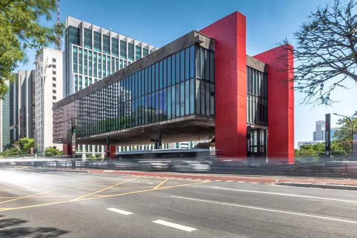
São Paulo – 12,25 million
The largest city in Brazil is also the largest in the southern hemisphere and in the Americas.
São Paulo is the main economic center of South America. Of all multinationals present in Brazil, the headquarters of about 63% of them are in the city, which is also responsible for over 30% of the Brazilian GDP.

Rio de Janeiro – 6,72 million
Known as the Marvelous City, Rio de Janeiro is the leading international tourist destination in Brazil, Latin America, and the southern hemisphere.
Part of the city is considered a World Heritage Site by UNESCO, and the capital has a strong cultural influence in the country and in the world.
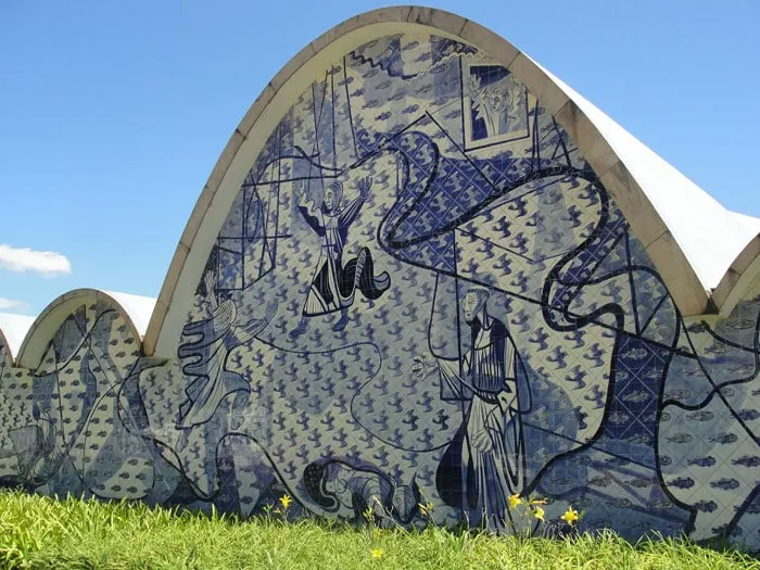
Brasília – 3,02 million
The country’s capital is the largest 20th-century city in the world. Built based on an urban plan developed by Oscar Niemeyer, the city has the shape of an airplane.
Brasilia is the seat of the three branches of the Republic (Executive, Legislative, and Judiciary). It is also the seat of 127 foreign embassies.
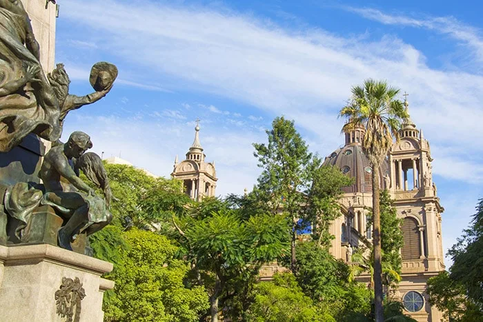
Salvador – 2,87 million
One of the first cities in the Americas, Salvador was the first national capital of Brazil during the Portuguese colonization period.
Due to the strong African influence that is very characteristic of Bahian culture, it is considered the main center of Afro-Brazilian culture.
Fortaleza – 2,67 million
The second most desired destination to visit in Brazil, according to the Ministry of Tourism.
Fortaleza gets its name from the Schoonenborch Fort, built in the 15th century during the Dutch occupation of the region. It is the closest Brazilian capital to Europe.
Belo Horizonte – 2,51 million
Comprising vast geography with hills and plains, Belo Horizonte is surrounded by the Serra do Curral. The city was founded to be the political and administrative capital of the state of Minas Gerais.
It is a very influential city in political, cultural, and economic terms. Recently it has been highlighted by the growth of cutting-edge technology companies in the area, especially biotechnology and informatics.

Manaus – 2,18 million
Founded in the meeting area of the Rivers Negro and Solimões, Manaus is the largest city in the Amazon region and the 10th major tourist destination in the country.
Its name comes as a tribute to Manaós, the indigenous community that inhabited the region. In the golden age of rubber, this city was known as the “Heart of the Amazon.”
Curitiba – 1,93 million
Curitiba emerged from a Bandeirante settlement that later became an important commercial hub with the creation of the road between Sorocaba-SP and Viamão-RS.
Thus, the city had significant urban development and attracted several European immigrants, mainly from Germany, Poland, Ukraine, and Italy.
Recife – 1,65 million
The oldest of the state capitals in the country, Recife, is home to the richest North-Northeast urban agglomeration and has the highest GDP per capita in the Northeast.
As one of the most influential capital cities in the region, it is still the city with the most headquarters of foreign consulates outside the Rio-São Paulo axis.
Porto Alegre – 1,48 million
The southernmost capital has the best Human Development Index in the country. It is the second most vertical capital, with 37.7% of the population living in apartments.
With one of the best national infrastructures, Porto Alegre is also one of the cities with the greenest areas and highest literacy levels in the country, making it very attractive for expats.

A brief history of the map of Brazil
- In 1504, the Portuguese started dividing the lands under their control into 14 hereditary captaincies. Names like Espírito Santo, Pernambuco, Maranhão, and Ceará were already used at the time.
- In 1750, it began the territorial expansion inland with the Treaty of Madrid. Grão-Pará and São Paulo are created, and later SP is divided into the states of Goiás, Minas Gerais, and Mato Grosso.
- In 1822, there were 17 states in Brazil, plus the Cisplatina, area where Uruguay is today.
- In 1889, with the installment of the Republic, the map of Brazil looked even more similar to the current configuration.
- In 1904, Brazil bought Acre State from Bolivia.
- In 1942, Brazil created the states of Roraima and Amapá and the island Fernando de Noronha.
- In 1946, the state of Rondônia was created.
- In 1960, is created Brasília in the state of Goiás.
- In 1979, Goiás was redesigned to create the state of Mato Grosso do Sul.
- In 1988, our constitution was installed. The Constitution of 1988 defined the current divisions of the map of Brazil. It also created the youngest state of Brazil in 1989, Tocantins.
Fun fact about the country
Brazil National Flag depicts the starry night on November 15, 1889, the Proclamation of the Republic.
This is an interesting fact because the stars represent not only this Brazilian holiday but also the 26 states and national capital.
Brazil map download
I have prepared a few free types of maps of Brazil for you.
- Click here to download the Brazil map outline.
- Click here to download the Brazil map with states (outlined).
- Click here to download the political map of Brazil.
- Click here to download the map of the regions in Brazil.
- Click here to download the map of South America.
Brazil travel resources
I hope you learned a lot about the formation of the current map of Brazil as well as its states.
You can use the Brazil maps above for school or personal projects, but please don’t use them for commercial purposes.
If you’re planning a trip to Brazil, be sure to read up on my best tips to get around the country and get the most out of your journey.
Did you like this post about the map of Brazil? Then share it with your friends who might like it too.
Monna
Thursday 11th of March 2021
The states of Goias and Mato Grosso were misplaced.
Bruna
Wednesday 17th of March 2021
Whops! I missed that. Thanks, Monna. Updated!